

Site and route analysis
Gain clarity on the site, access routes, and potential of your planned PV, BESS, or substation project
The first step for your solar, storage, and substation projects
For photovoltaic systems (PV), battery energy storage systems (BESS), and substations (UW)
With our site and route analysis, including site inspection and 3D terrain modeling, we create the foundation for realistic and efficient project design. You receive all relevant information about your PV, BESS, or substation site – from topographical features and access routes to shading objects.
This enables you to make informed decisions early on and optimally align your project both technically and economically.

Components of our analysis
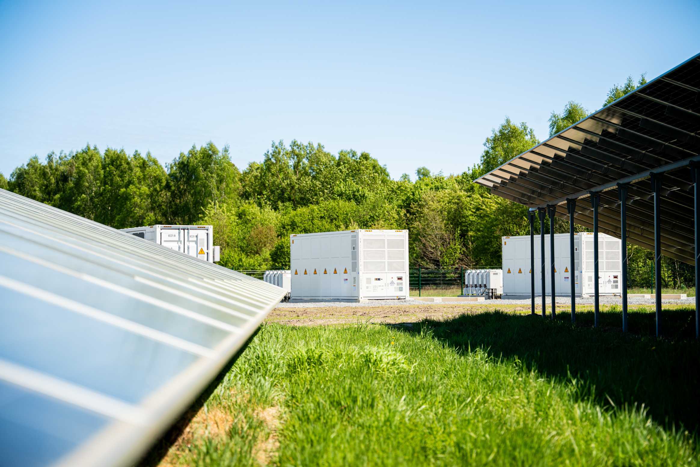
Detailed on-site survey of site & routes
Our site and route analysis provides you with a precise survey of all relevant on-site information for your project. We survey the terrain, access routes, potential shading objects, and suitable positions for transformers or service roads. This gives you a solid basis for realistic and efficient construction and operational planning.
- Inspection of the site and access routes
- Survey and description of the site including video and photo documentation to determine possible access for construction and operation, positions for transformer stations, switchgear, BESS containers, gates, service roads
- Estimation of heavy-duty traffic volume during the construction phase / swept path analysis


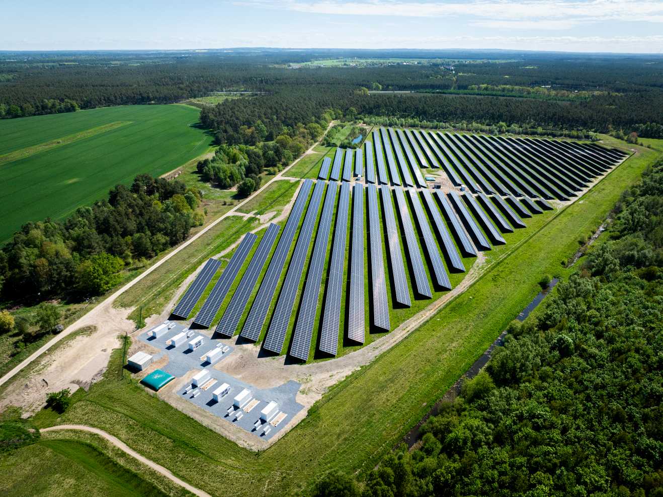
Precise 3D Terrain Model
With the 3D terrain model, we create a detailed, drone-based representation of your site, including topographical features and shading objects. The georeferenced model is “PVcase-ready” and enables a precise design of your PV, BESS or substation system in the layout software. This allows for the optimal system design to be determined down to the centimeter, the corresponding yield simulation (PV) to be created, and an informed investment decision to be made based on the results.
- Drone flight over the site
- Creation of a georeferenced AutoCAD model
“PVcase-ready” including shading objects (e.g., trees)
4 good reasons for our analysis
Our site and route analysis forms the basis for informed project decisions and future planning

Foundation for sound decisions
You receive precise information about your site – including topographical features, infrastructure, and technical details – thereby creating the basis for sound investment decisions.

Realistic and efficient system design
The more accurate the site data, the better the subsequent system design can be planned and optimized, ensuring maximum yields, economic efficiency, and a smooth project execution from the outset.

Create security - minimize planning risks
By site inspection, surveying access roads, shading objects, and non-buildable areas, as well as an optional 3D terrain model, you can identify potential risks early and make appropriate decisions.
Experience from hundreds of projects
Our engineers are familiar with the requirements for sites of modern PV, BESS and substation systems. They quickly identify potential or challenges of the site – for a realistic design and implementable solutions.
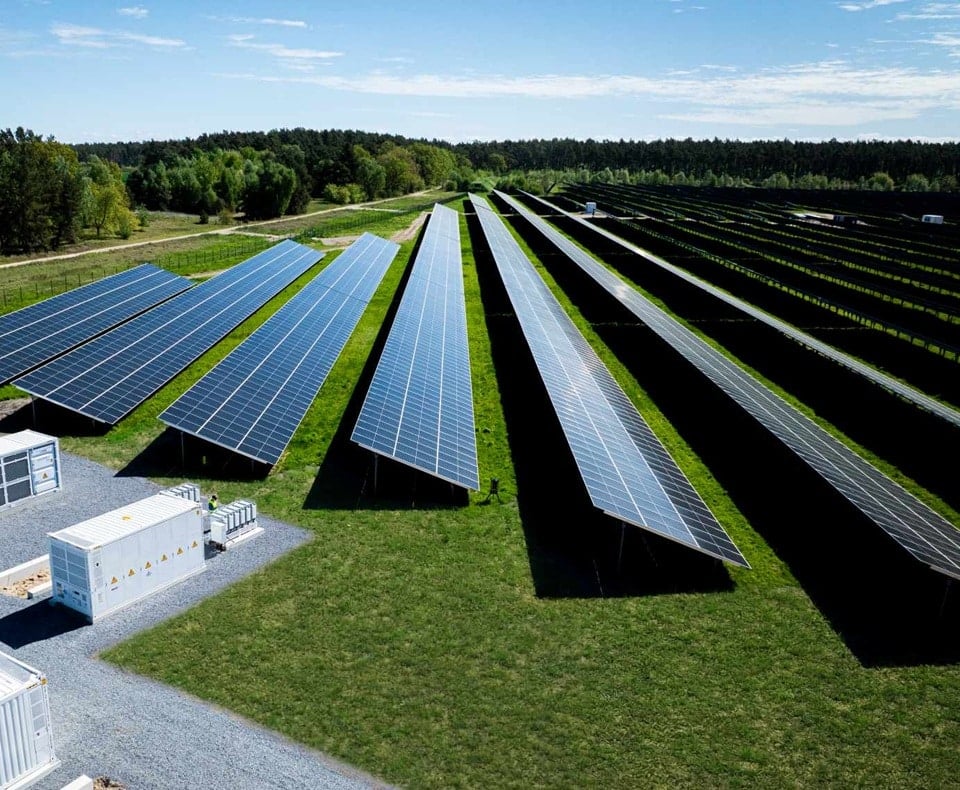
Shading analysis for maximum yield
To assess the full potential of a site, we examine possible shading sources and their impact on future energy generation during the site inspection and 3D terrain modeling. For this purpose, we collect all relevant structures in the vicinity, such as trees, buildings, topography, and technical infrastructure and evaluate them in relation to the designed construction project.
As part of the preliminary design or the creation of yield assessments and associated irradiation simulations, we can precisely determine how shadow patterns change throughout the year and what impact they have on system design and expected yield. This allows for early decisions on whether adjustments to the design, row spacing, or land use are sensible to avoid yield losses.

Our range of services in detail

Site analysis services
Inspection of the site and access routes
Survey and description of the site including video and photo documentation to determine possible access for construction and operation, positions for transformer stations, BESS containers, a substation, gates, service roads,…
Estimation of heavy-duty traffic volume during the construction phase / swept path analysis
Capturing of the shading situation through images and detailed description
Tabular representation of recorded routes and special features

3D Terrain Model services
Capturing of the terrain profile in the Digital Elevation Model (DEM) for use in AutoCAD
When is a site and route analysis useful?
In early project development
A site analysis is useful as soon as a potential site of land comes into view, to quickly check whether the site is fundamentally suitable for the construction of a PV, BESS or substation system.
For technical feasibility studies
It helps to realistically assess topographical features, shading elements, soil conditions, or setback areas, thereby ensuring technical feasibility.
For informed site and system planning
PV sites: Exact site data allow for early design of module arrangement, row spacing, and cable routing to enable maximum yields and efficient operation.
BESS sites: A precise site analysis enables the sensible placement of BESS containers, inverters, and auxiliary systems. Distances, access routes, and maintenance areas are considered early on, ensuring safe and efficient operation.
Substation sites: For substations, a thorough site analysis provides the basis for optimal positioning. Short route distances, good accessibility, and compliance with grid operator-specific requirements can thus be considered in the early planning phase.
As a decision-making basis for investors or owners
It provides a reliable assessment of whether project development on the specific site is economically viable and what potential can be realized.
Before submitting approval documents
A thorough analysis ensures that plans, site sizes, distances, and usage limits are correctly incorporated into approval and construction documents.
For projects with complex or unclear sites
Especially for sloped sites, irregular plot shapes, or areas with many interfering objects, the analysis creates transparency and prevents later planning errors.
To minimize risks in the further course of the project
A detailed site analysis uncovers potential problems early, such as shading risks, inadequate access, or flood hazards, before they cause costs or delays.
Why work with greentech?
Years of experience
Employees active in 6 European countries
Projects in the development pipeline
Ground-mounted PV systems built

in technical consulting
in operational management
Your specialists for
site and route analysis

Viola Hoffmann
Commercial Head of Engineering

Johannes Liebich
Head of Engineering & Technical Advisory

Joern Carstensen
Chief Technical Officer (CTO)
In his role, Jörn Carstensen combines the management of all technical areas of the greentech group. As CTO, he is responsible for plant construction, engineering services and technical management. The aim is to create uniform standards and processes across all technical areas at greentech, thereby ensuring company-wide synergies, high quality and the greatest possible transparency.
Jörn Carstensen joined greentech in 2014 as Business Development Manager. In addition to developing various European markets, he built up the Engineering and Technical Advisory division. From 2006 to 2014, he worked for the Conergy Group in various international corporate and business development positions. Prior to that, he worked for a consulting unit of Accenture and supported utility companies in strategic and organisational issues. Jörn Carstensen holds a degree in Industrial Engineering with a specialisation in Energy and Environmental Management from the Universities of Flensburg and Southampton.
Contact
Only 45 seconds for your request
FAQ: Site and Route Analysis
Frequently asked questions about site assessment, site inspection, and route verification – including 3D terrain model, shading, and layout.
What is a site and route analysis and what is its purpose?
Site and route analyses for PV, BESS, or substations provide all relevant information on terrain, access roads, shading objects, and possible system positions to make design, approval, and construction realistic and efficient.
What is a site analysis?
The site analysis forms the basis for realistic and economic system planning. Based on precise site data, we evaluate the actual usability of the project area and identify relevant restrictions such as topography, cuts, distances, or exclusion zones. This allows for optimal early determination of module arrangement, row spacing, container and substation locations, and internal cable routing. The result is a robust site layout that considers technical feasibility, yield potential, and efficient operation from the outset.
What is a route analysis?
A route analysis examines the paths by which a system is accessed during construction and operation, especially for heavy and delivery traffic. We exclusively consider the navigability of access routes, for example, regarding permissible axle and total weights, clearance heights, curve radii, and swept paths. The goal is to ensure early on that components such as modules, containers, transformers, or cranes can be transported to the site without restrictions – regardless of the later route or line routing.
Who should commission a site and route analysis?
Owners, project developers, and investors who need to make informed decisions for PV, BESS, or substation projects or require an independent assessment of site conditions.
Which methods are used in site analysis?
We combine on-site inspections, upon request or as needed, with high-resolution drone imagery and optional 3D terrain models for exact, georeferenced data.
What are the benefits of a site and route analysis from greentech?
You receive an informed decision-making basis, can optimize system designs, identify risks early, and integrate the results directly into project design.
What does the site inspection include?
Survey of the site, access roads, potential transformer stations, service roads, and assessment of construction and operational risks.
What additional benefits does the 3D terrain model provide?
A detailed, georeferenced model with 3D terrain profile, shading objects, and optional orthomosaic or 360° panorama, which can be used directly in design softwares.
How does the analysis help with system design?
The precise site data enable an optimal system design tailored to the site, precise yield simulations based on this, and thus economically sound decisions.
How does the site analysis ensure that shading does not impair system performance?
We analyse all potential shading elements using precise 3D simulations and annual profiles. This allows us to identify early how buildings, trees, or terrain features could affect the system, and adjust the system design accordingly. This protects yields, minimizes risks, and ensures trouble-free operation in the long term.
Can the site analysis also review existing site analyses?
Yes, as Owner’s Engineer, we can review existing site analyses and provide a neutral second opinion.
What do I receive as a result of the site and route analysis?
Depending on the project size, the results are summarized in a comprehensive report, including all relevant data, images, and models.
Is the analysis also relevant for the construction and operational phase?
Yes, information on access roads, heavy-duty traffic, swept paths, and infrastructure significantly supports construction and operational planning.
Still have questions?
Can’t find the answer you’re looking for? Please get in touch with our team of experts
Engineering & Technical Advisory
Here you can download an overview of our Engineering & Technical Advisory services:
